
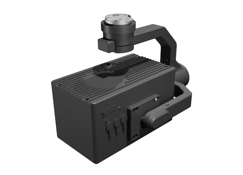
HM-9010-U Visible/Near-Infrared Multispectral Payload
HM-9010-U is a high-performance airborne multispectral imaging system combining a multispectral camera, an HD visible-light camera, and an optional thermal-IR module for precision agriculture, environmental monitoring, and research. The multispectral camera has 7 channels covering blue, green, red, red-edge, and near-IR, a sensor with 500 × ten thousand pixels, and a 72° field of view. The visible camera has 1200 × ten thousand pixels and an 82° wide angle for high-resolution acquisition. Postprocessing software geometrically corrects images to obtain multispectral digital orthophotos. Compatible with DJI M400 UAVs, it calculates and displays vegetation indices in real time, with broad compatibility and high stability for complex operating environments.
 Save to Favorites
Overview
Specifications
| Parameter | Value |
|---|---|
| Multispectral Camera - Multispectral Sensor | 500 × Ten Thousand Pixels; 1/1.8 Inches |
| Multispectral Camera-Spectral Channel(Default)-Blue(B) | 450nm±10nm |
| Multispectral Camera-Spectral Channel(Default)-Green(G) | 530nm±3nm |
| Multispectral Camera-Spectral Channel(Default)-Green(G) | 560nm±10nm |
| Multispectral Camera - Spectral Channel(Default) - Red(R) | 660nm±10nm |
| Multispectral Camera - Spectral Channel(Default) - Red Edge(RE) | 720nm±5nm |
| Multispectral Camera - Spectral Channel(Default) - Red Edge(RE) | 750nm±5nm |
| Multispectral Camera - Spectral Channel(Default) - Near-IR(NIR) | 850nm±15nm |
| Multispectral Camera - Field of View -DFOV | 75° |
| Multispectral Camera - Lens Focal Length | Focal Length 5.5mm |
| Multispectral Camera - Aperture | F/1.6 |
| Multispectral Camera - Ground Sampling Distance(GSD) [H Is the Aircraft Flight Height Relative to the Mapping Area (Unit: Meters)] | H×0.05 m/pixel |
| Multispectral Camera - Maximum Photo Resolution | 2448 x 2048 |
| Multispectral Camera - Photo Format | TIFF |
| HD Visible Camera - Sensor | 1200W Pixels; 1/1.1 Inches |
| HD Visible Camera - Lens Focal Length | 8mm |
| HD Visible Camera - Aperture | F/4.0 |
| HD Visible Camera - Field of View - DFOV | 82° |
| HD Visible Camera - Ground Resolution [H Is the Aircraft Flight Height Relative to the Mapping Area (Unit: Meters)] | H×0.034 m/pixel |
| HD Visible Camera - Maximum Photo Resolution | 4096 (H)x 3000 (V) |
| Thermal IR(Optional) - Video Resolution [25Hz/30Hz] | 640×512 |
| Thermal IR(Optional) - Field of View - DFOV | 45.2° |
| Thermal IR(Optional) - Video Format | MP4 |
| Thermal IR(Optional) - Pixel Pitch | 12 μm |
| Thermal IR(Optional) - Wavelength Range | 8 μm 至 14 μm |
| Thermal IR(Optional) - Noise Equivalent Temperature Difference(NETD) | ≤ 30 mK |
| Thermal IR(Optional) - Temperature Measurement Range | -20℃~150℃ , 0℃~550℃ |
| Compatible UAV | DJI M400 |
| Gimbal Mechanical Interface | DJI Xport |
| Drone Dock Compatibility | Compatible with M400-Based Drone Docks for Dual-Payload Mounting |
| Real-Time Calculation and Display | Real-Time Calculation and Rendering of Multiple Vegetation Values (NDVI\\GNDVI\\NDRE\\OSAVI\\LCI), with Ground-Terminal Display |
| Supported File Systems | FAT32(32GB); exFAT(>32GB) |
| Supported Memory Card Types | Use a microSD™ UHS-I Memory Card Rated U3 / V30 / A2 or Higher; Supports Capacities up to 1TB |
| Other - Storage Temperature [20% ~ 80%RH, non-condensing] | -20-60℃ |
| Other - Operating Ambient Temperature [20% ~ 80%RH, non-condensing] | 0℃至40℃ |
Applications
Key Features
Datasheet
Please provide your email to download the datasheet.
Invalid email format. Please try again.
Supplier Information
Related Products
-
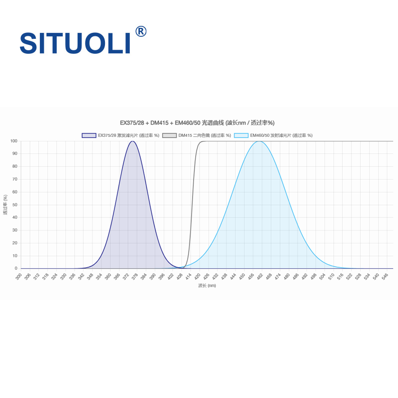 FL375FF Bandpass Fluorescence Excitation Block
Research & Education
Situoli
EX375/28 Excitation Filter - Center Wavelength: 375nm EX375/28 Excitation Filter - Half Bandwidth: 28nm EX375/28 Excitation Filter - Effective Wavelength Band [UV Narrowband Excitation]: 361nm ~ 389nm
Full product name: Fluorescence microscopy Mirror Unit, bandpass fluorescence excitation block. Optical configuration: excitation filter EX375/28 + dichroic beamsplitter DM415 + emission filter EM460/50. Standard accessory: dedicated protective storage case (including case). Compatible fluorescence systems: DAPI, 1,8-ANS, Acridine, BFP, Marina Blue, sgBFP and Uvitex SFC.
-
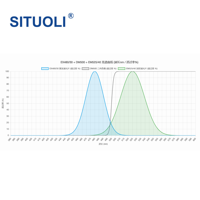 FL480NFF Bandpass Fluorescence Excitation Block
Research & Education
Situoli
EX480/30 Excitation Filter - Center Wavelength: 480nm EX480/30 Excitation Filter - Half Bandwidth: 30nm EX480/30 Excitation Filter - Effective Wavelength Band [Blue Narrowband Excitation]: 465nm ~ 495nm
Full product name: Fluorescence microscopy Mirror Unit, bandpass fluorescence excitation block. Optical configuration: excitation filter EX480/30 + dichroic beamsplitter DM500 + emission filter EM525/40. Standard accessory: dedicated protective storage case (including case). Compatible fluorescence systems: GFP, FITC, Cy2, AlexaFluor488, BODIPY 492/515, Calcein and Evans Blue.
-
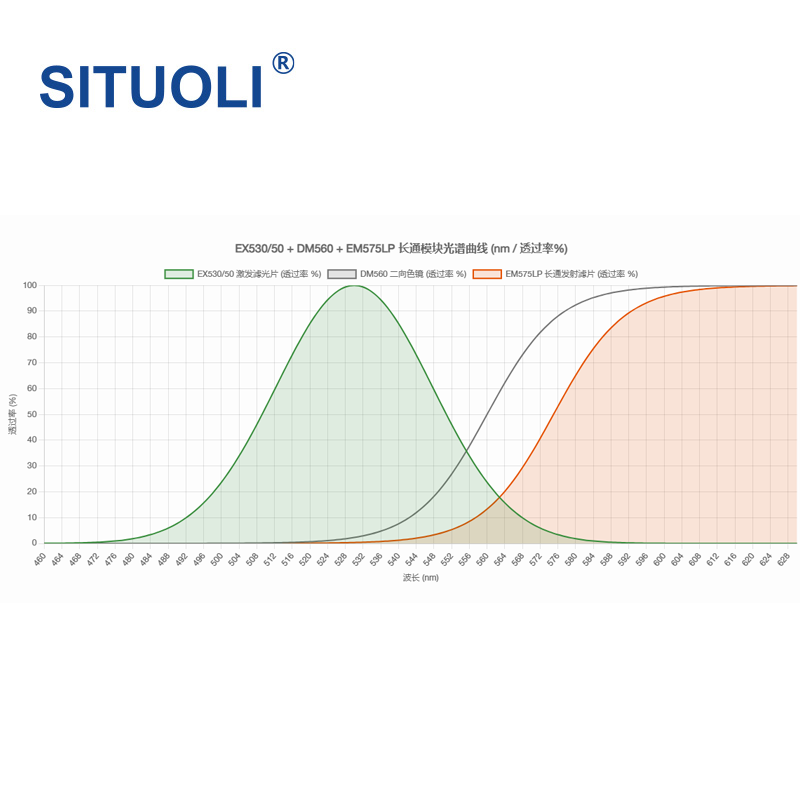 FL530FF-LP Longpass Fluorescence Excitation Block
Research & Education
Situoli
EX530/50 Excitation Filter - Center Wavelength: 530nm EX530/50 Excitation Filter - Half Bandwidth: 50nm EX530/50 Excitation Filter - Effective Wavelength Band [Green Broadband Excitation]: 505nm ~ 555nm
Full product name: Fluorescence microscopy Mirror Unit, longpass fluorescence excitation block. Optical configuration: excitation filter EX530/50 + dichroic beamsplitter DM560 + emission filter EM575LP. Standard accessory: dedicated protective storage case (including case). Compatible fluorescence systems: Cy3, TRITC, Rhodamine, Alexa Fluor 546 and orange-red fluorescent dyes. Full product name: Fluorescence microscopy Mirror Unit, longpass fluorescence excitation block. Optical configuration: excitation filter EX530/50 + dichroic beamsplitter DM580 + emission filter EM590LP. Standard accessory: dedicated protective storage case (including case). Compatible fluorescence systems: TRITC, Cy3, Rhodamine, Alexa Fluor 546, orange-red fluorescent proteins and longpass green-excitation systems.
-
 FL475FF Bandpass Fluorescence Excitation Block
Research & Education
Situoli
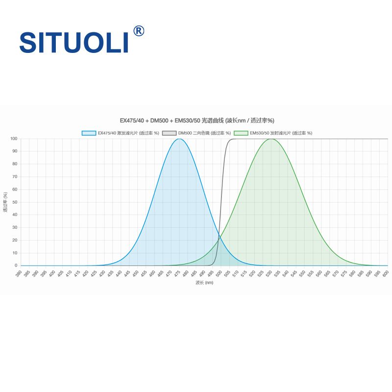
EX475/40 Excitation Filter - Center Wavelength: 475nm EX475/40 Excitation Filter - Half Bandwidth: 40nm EX475/40 Excitation Filter - Effective Wavelength Band [Blue Broadband Excitation]: 455nm ~ 495nm
Full product name: Fluorescence microscopy Mirror Unit, bandpass fluorescence excitation block. Optical configuration: excitation filter EX475/40 + dichroic beamsplitter DM500 + emission filter EM530/50. Standard accessory: dedicated protective storage case (including case). Compatible fluorescence systems: GFP, FITC, Cy2, AlexaFluor488, BODIPY 492/515, Calcein and Evans Blue.
-
 FL365NFF Bandpass Fluorescence Excitation Block
Research & Education
Situoli
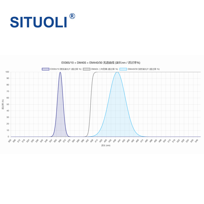
EX365/10 Excitation Filter - Center Wavelength: 365nm EX365/10 Excitation Filter - Half Bandwidth: 10nm EX365/10 Excitation Filter - Effective Wavelength Band [UV Narrowband Excitation]: 360nm ~ 370nm
Full product name: Fluorescence microscopy Mirror Unit, bandpass fluorescence excitation block. Optical configuration: excitation filter EX365/10 + dichroic beamsplitter DM405 + emission filter EM440/30. Standard accessory: dedicated protective storage case (including case). Compatible fluorescence systems: DAPI, Hoechst, AlexaFluor350, BFP, Calcofluor White, DyLight 350 and Fast Blue.
Related Articles
Laser pump sources are the core energy input component of solid-state lasers and laser amplifiers, and their performance directly determines the output power, beam quality and service life of the entire laser system. In scenarios such as industrial processing, scientific research experiments and high-end equipment, improper pump source selection will not only result in substandard system performance, but also bring a series of problems such as rapid device degradation and high operation and maintenance costs. This article sorts out the core selection logic and key pitfalls of pump source procurement, and provides selection references based on mature, mass-produced high-reliability products to help purchasers efficiently screen suitable products.
Shandong Haucore Optoelectronics Co., Ltd. introduces the HGLD‑792‑COS‑D‑10WB semiconductor laser within its COS series. Delivering an output power of 10 W at a central wavelength of 792 nm, this device adopts gold‑tin bonding COS packaging. Featuring high reliability and long service life, it serves as a preferred pump source for solid‑state lasers and is widely deployed in industrial processing, laser display, medical & aesthetic treatment, scientific research and other fields.
Fomoptic delivers integrated one‑stop optical solutions covering precision optical fabrication and custom vacuum coating services. Supported by complete processing production lines, comprehensive metrology equipment and experienced engineering team, we provide full‑chain customized components, ranging from blank shaping, ultra‑precision polishing to thin‑film coating, for laser systems, infrared imaging, industrial optics and scientific‑research projects.
Fiber lasers and fiber amplification systems require excitation sources with stable wavelength, narrow spectral linewidth and consistent output power.
Loading...
Name
Phone
Organization
Use Case

Database Platform